Analisis Performansi Mobile Tracking Berbasis Sistem Seluler dengan Metode A-GPS
Diki Muhammad

Informasi Umum
Kode
111080112
Klasifikasi
621.382 16 -
Jenis
Karya Ilmiah - Skripsi (S1) - Reference
Subjek
Transmisi Telkom
Dilihat
17 kali
Informasi Lainnya
Abstraksi
ABSTRAKSI: Location Based Services (LBS) merupakan suatu inovasi dalam dunia telekomunikasi seluler yang mampu memberikan layanan dan informasi yang sesuai dengan letak geografis dan koordinat pengaksesnya. Untuk mendukung ketepatan layanan dan informasi yang diberikan, maka diperlukan tingkat keakurasian penentuan posisi user yang baik. Dalam menentukan posisi user, terdapat berbagai macam metode, antara lain adalah: RSS, AOA, TOA, EOTD, GPS, dan A-GPS.<br><br>A-GPS merupakan metode penentuan posisi dengan menggunakan satelit. Sehingga, dalam propagasi sinyal GPS dari satelit ke user, akan terdapat delay yang diakibatkan oleh atmosfer (ionosfer dan troposfer). Di dalam Tugas Akhir ini, penelitian dilakukan untuk mengetahui performansi penentuan posisi dengan menggunakan metode A-GPS. Disamping itu, juga untuk mengetahui pengaruh dari sebaran satelit dan pengaruh dari kecepatan pergerakan user terhadap tingkat keakurasian penentuan posisi user dengan menggunakan metode ini.<br><br>Hasil dari penelitian ini menunjukkan bahwa sebaran satelit dan kecepatan user telah mempengaruhi tingkat keakurasian penentuan posisi user. Sebaran satelit memiliki pengaruh yang cukup signifikan. Rata-rata kesalahan ketika sebaran satelitnya berdekatan, dapat mencapai 6,9276 meter, sedangkan ketika sebaran satelitnya tersebar, rata-rata kesalahan dalam penentuan posisi user bisa ditekan sampai dengan 32,40%, yakni rata-rata kesalahannya adalah sebesar 4,6825 meter. Sedangkan pengaruh dari kecepatan user tidak terlalu signifikan, dimana perbedaan kesalahan rata-rata saat user diam (0 km/h) dan saat user bergerak dengan kecepatan 100 km/h hanya sebesar 1,7531 meter saja.Kata Kunci : LBS (Location Based Services), GIS (Geographic Information System),ABSTRACT: Location Based Services (LBS) is an innovation in the telecommunications engineering which capable to provide the services and the informations in accordance with the geographical location and coordinates of its user. In order to meet the proper services and informations that provided, so it requires a good accuracy level of determining the user's position. In determining the user's position, there are a variety of methods that can be used, such as: RSS, AOA, TOA, EOTD, GPS, and A-GPS.<br><br>A-GPS is a method of determining the user's position by using satellites. Therefore, in the signal propagation from the satellites to the user, there will be time delay due to the atmosphere (ionosphere and troposphere). In the final, the research is conducted to determine the performance of position determination using A-GPS method. Besides that, this is also to find out the influence of satellites spread and user's velocity to the performance and accuracy of A-GPS in determining the user's position.<br><br>The results of this research indicate that the satellites spread and user's velocity affect the level of positioning accuracy. Satellites spread has a significant influence. The average error when the satellites are adjacent, can achieve 6,9276 meters, whereas when the satellites spread are scattered, the average error in the determination of user position can be reduced up to 32,40%, which the average error is equal to 4,6825 meters. Whereas the influence of the user's velocity is not significant, which the difference of the average error when the user isn't moving (0 km/h) and when the user is moving with a speed of 100 km/h only amounted to 1,7531 meters.Keyword: LBS (Location Based Services), GIS (Geographic Information System),
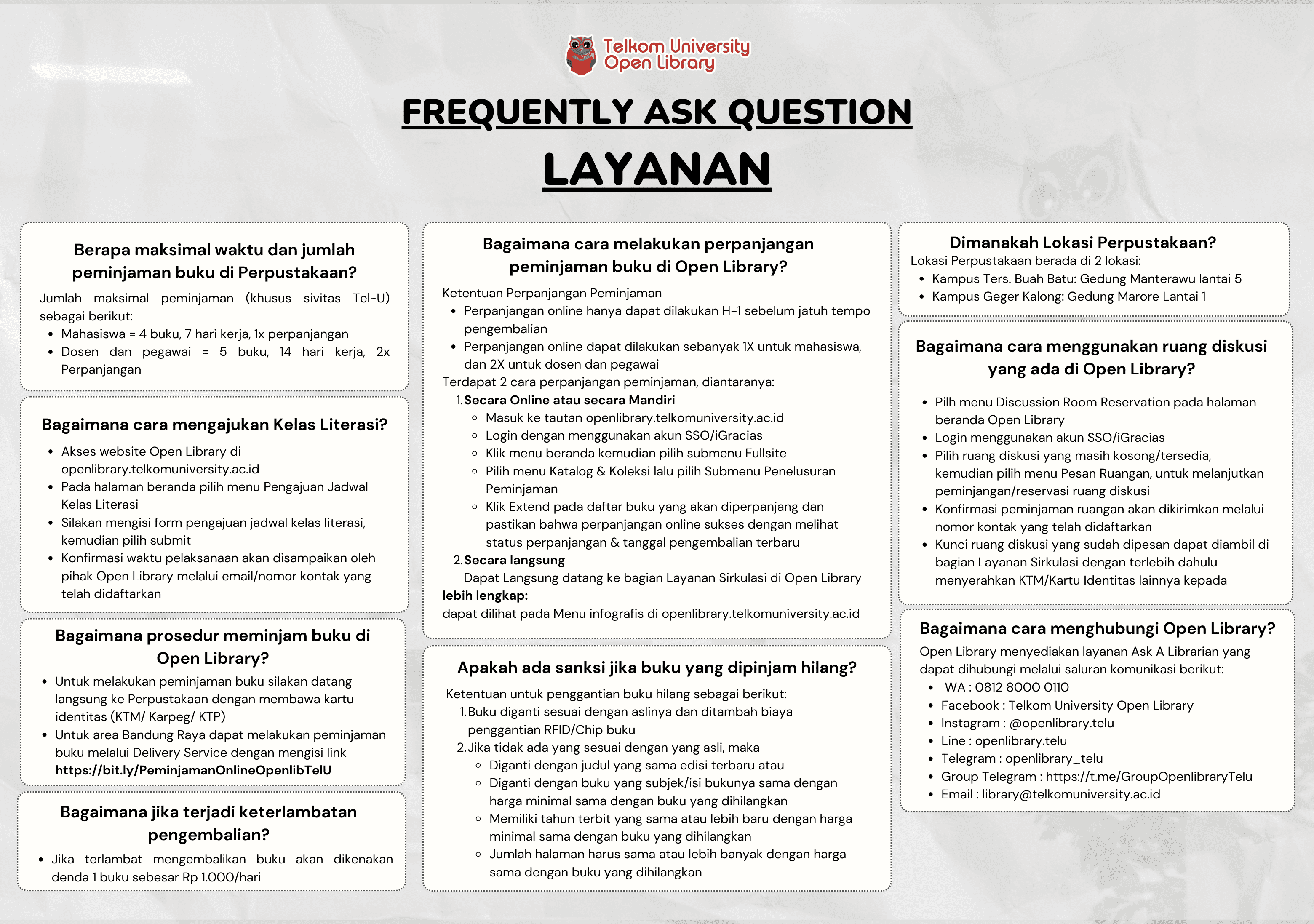
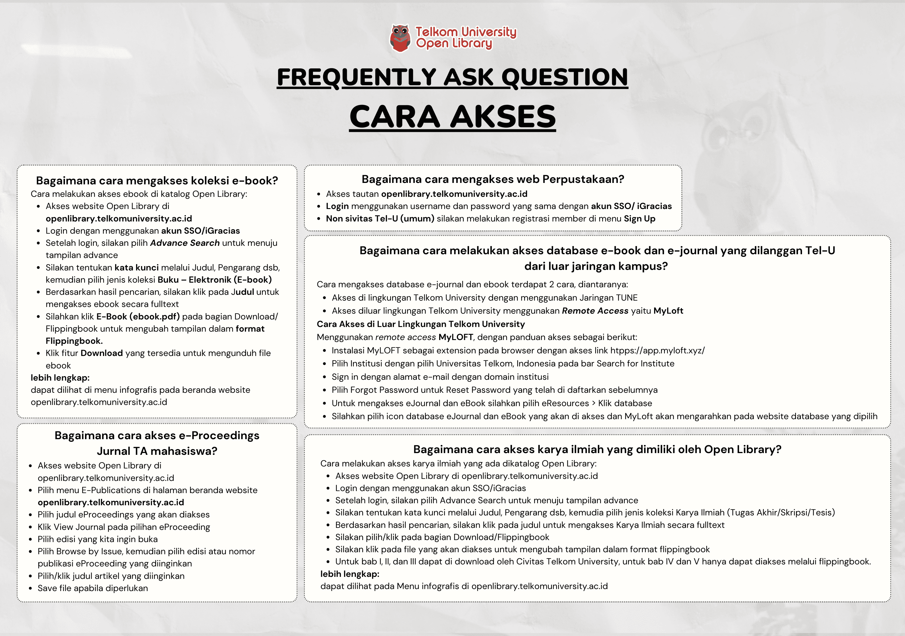
Koleksi & Sirkulasi
Tersedia 1 dari total 1 Koleksi
Anda harus log in untuk mengakses flippingbook
Pengarang
| Nama | Diki Muhammad |
| Jenis | Perorangan |
| Penyunting | Nachwan Mufti, Tody Ariefianto Wibowo |
| Penerjemah |
Penerbit
| Nama | Universitas Telkom |
| Kota | Bandung |
| Tahun | 2012 |
Sirkulasi
| Harga sewa | IDR 0,00 |
| Denda harian | IDR 0,00 |
| Jenis | Non-Sirkulasi |