IDENTIFIKASI TIPE WILAYAH URBAN, SUBURBAN, DAN RURAL BERBASIS PENGOLAHAN CITRA PENGINDERAAN JARAK JAUH
Ratri Andaruresmi

Informasi Umum
Kode
111040020
Klasifikasi
621.382 2 - Signal processing, Information theory
Jenis
Karya Ilmiah - Skripsi (S1) - Reference
Subjek
Pengolahan Sinyal Informasi
Dilihat
909 kali
Informasi Lainnya
Abstraksi
ABSTRAKSI: Kemajuan teknologi di bidang informasi memotivasi manusia untuk menciptakan suatu sistem yang dapat mengidentifikasi tipe wilayah menggunakan citra penginderaan jarak jauh sebagai masukan awal pengolahan citra digital. Pada tugas akhir ini yang menjadi objek penelitian adalah citra penginderaan jarak jauh google earth. Citra penginderaan jarak jauh google earth adalah pencitraan yang dilakukan oleh satelit dimana digunakan sebagai bahan analisis.<br>Melalui pengolahan citra, citra masukan diproses awal menggunakan transformasi wavelet yang digunakan untuk ekstraksi ciri. Transformasi wavelet menghasilkan representasi multi resolusi dari citra aslinya. Untuk identifikasi citra penginderaan jarak jauh google earth tersebut harus dilakukan beberapa tahapan, yaitu akuisisi citra, pengolahan awal, ekstraksi ciri menggunakan 2D Gabor Wavelet dan terakhir pengenalan atau identifikasi menggunakan K-Nearest Neighbors (KNN).<br>Pada tugas akhir ini citra hasil penginderaan jarak jauh tersebut dikelompokkan ke dalam wilayah urban, suburban, dan rural. Selain itu pengujian dilakukan dengan program simulasi menggunakan perangkat Matlab 7.4. Sistem pengidentifikasi menggunakan K-Nearest Neighbors (KNN) ini dapat mengidentifikasi tipe wilayah untuk metode jarak Euclidean dengan tingkat keberhasilan 86,67%, untuk metode jarak Cityblock dengan tingkat keberhasilan 83,33%, dan tingkat akurasi jarak Mahalanobis sebesar 81,11%.Kata Kunci : Google Earth, Penginderaan Jarak Jauh, 2D Gabor Wavelet , K-Nearest NeighborsABSTRACT: The development of information technology has motivated people to create a system which is able to identify several types of area using remote sensing image as the initial state of the digital image processing. This study makes use of Google earth remote sensing images. The Google earth sensing is satellite based, where they are used as the analysis materials.<br>The initial image is processed using wavelet transform which is suitable for feature extraction. The wavelet transform provides the multi resolution representation from the original image. For the Google earth image identification, the process should be done in several steps, i.e., image acquisition, pre-processing, feature extraction using 2D Gabor Wavelet, and the identification using K-Nearest Neighbors (KNN).<br>In this final project, the result of the remote sensing image will be categorized into the urban, suburban and rural area. The evaluation is done using simulation on Matlab 7.4. The K-Nearest Neighbors (KNN) can identify the type of the area using three distance methods, namely Euclidean, Cityblock, and Mahalanobis. Those methods provide the success rate about 86.67%, 83.33%, and 81.11% respectively.Keyword: Google Earth, Remote Sensing, 2D Gabor Wavelet, K-Nearest Neighbors.
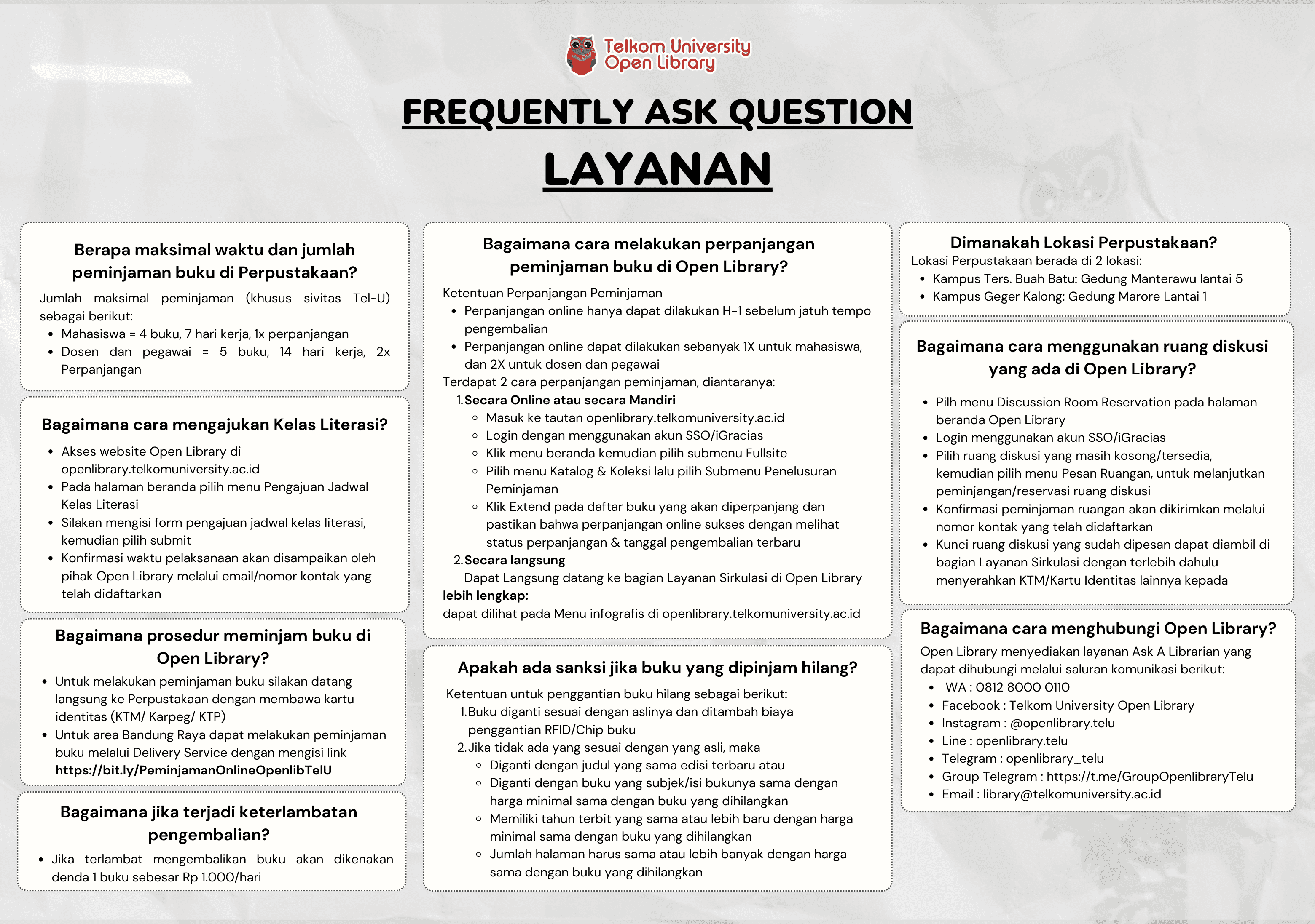
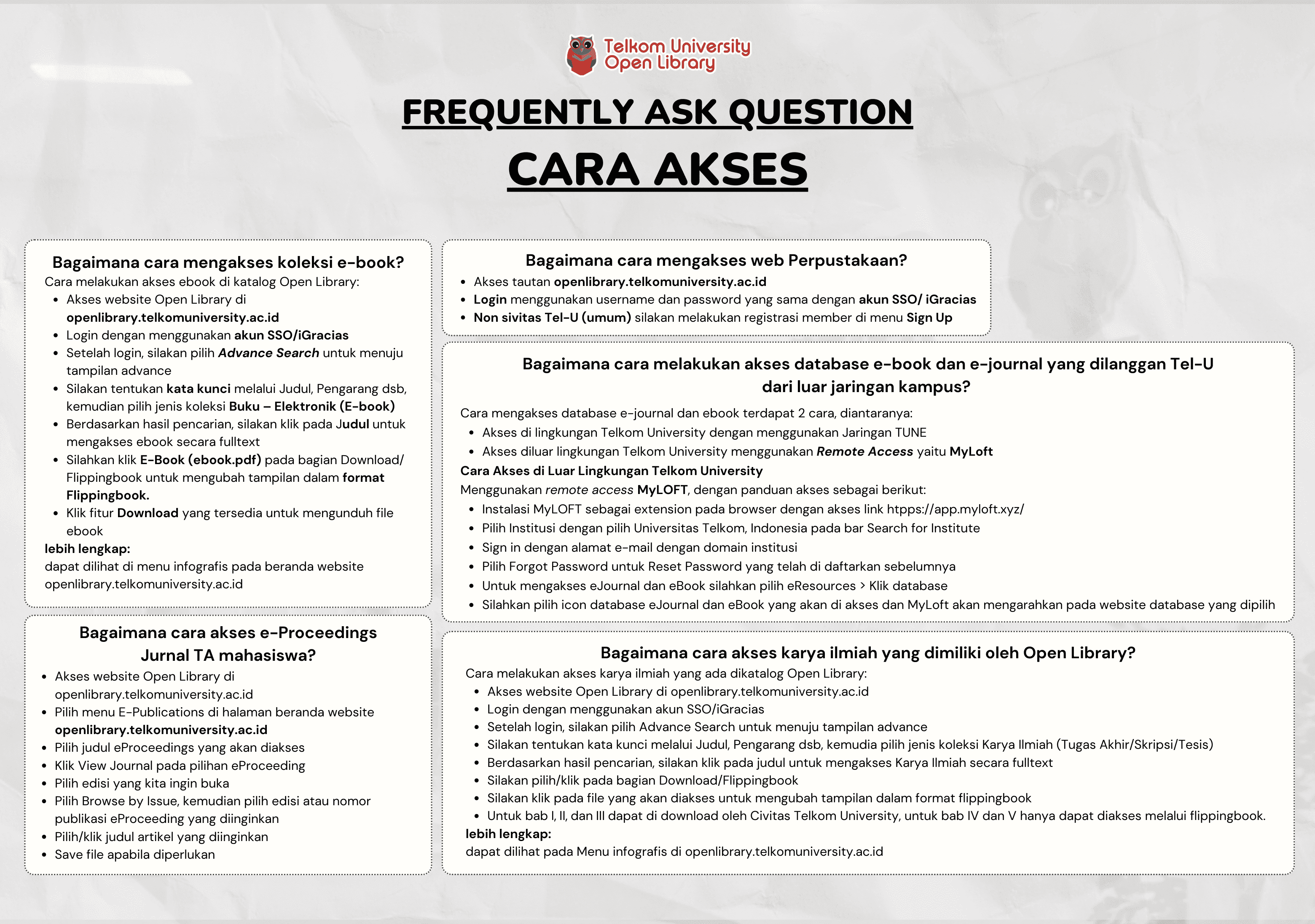
Koleksi & Sirkulasi
Tersedia 1 dari total 1 Koleksi
Anda harus log in untuk mengakses flippingbook
Pengarang
| Nama | Ratri Andaruresmi |
| Jenis | Perorangan |
| Penyunting | Achmad Rizal, Rita Magdalena |
| Penerjemah |
Penerbit
| Nama | Universitas Telkom |
| Kota | Bandung |
| Tahun | 2009 |
Sirkulasi
| Harga sewa | IDR 0,00 |
| Denda harian | IDR 0,00 |
| Jenis | Non-Sirkulasi |