Semantic Segmentation of Land Cover in Multisource Aerial Imagery using U-Net - Dalam bentuk buku karya ilmiah
SAYID RAYHAN MULACHELA

Informasi Umum
Kode
25.04.385
Klasifikasi
000 - General Works
Jenis
Karya Ilmiah - Skripsi (S1) - Reference
Subjek
Deep Learning
Dilihat
295 kali
Informasi Lainnya
Abstraksi
Accurate land cover segmentation in aerial imagery is vital for environmental monitoring and greenhouse gas (GHG) emissions assessment. This study applies the U-Net model for semantic segmentation of land cover types, including buildings, forests, water bodies, and roads, to analyze their impact on GHG emissions. Using the LandCover.ai dataset (1,200 images) and a supplementary dataset from Java, Indonesia (400 images), the research evaluates U-Net’s performance at the pixel level. The dataset was split into 70% training (840 images), 15% validation (180 images), and 15% testing (180 images). Metrics such as Intersection over Union (IoU) and Dice Coefficient were used for evaluation. The model achieved a mean IoU of 0.81 and a Dice Coefficient of 0.80 on the primary dataset, while performance declined with the Java dataset (mIoU 0.72, Dice 0.70), indicating generalization challenges. Data augmentation improved results to an mIoU of 0.82 and Dice 0.81. These findings highlight U-Net’s potential in remote sensi
- CCH3F3 - KECERDASAN BUATAN
- CIG4E3 - PENGOLAHAN CITRA DIGITAL
- CCH4D4 - TUGAS AKHIR
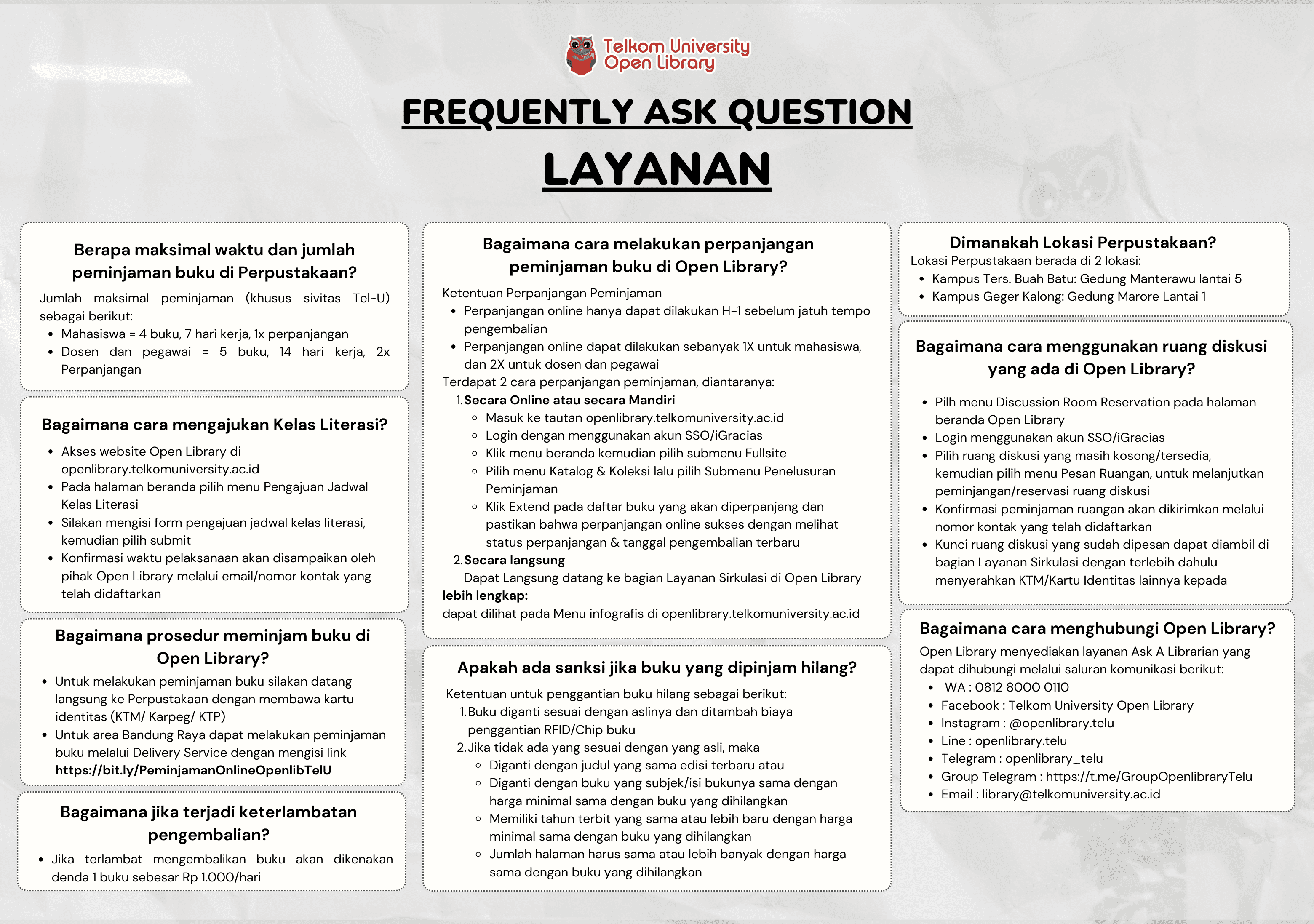
Koleksi & Sirkulasi
Tersedia 1 dari total 1 Koleksi
Anda harus log in untuk mengakses flippingbook
Pengarang
| Nama | SAYID RAYHAN MULACHELA |
| Jenis | Perorangan |
| Penyunting | Erwin Budi Setiawan, Gamma Kosala |
| Penerjemah |
Penerbit
| Nama | Universitas Telkom, S1 Informatika |
| Kota | Bandung |
| Tahun | 2025 |
Sirkulasi
| Harga sewa | IDR 0,00 |
| Denda harian | IDR 0,00 |
| Jenis | Non-Sirkulasi |