Satellite Image Analysis: Clustering and Classification
Surekha Borra, Rohit Thanki, Nilanjan Dey
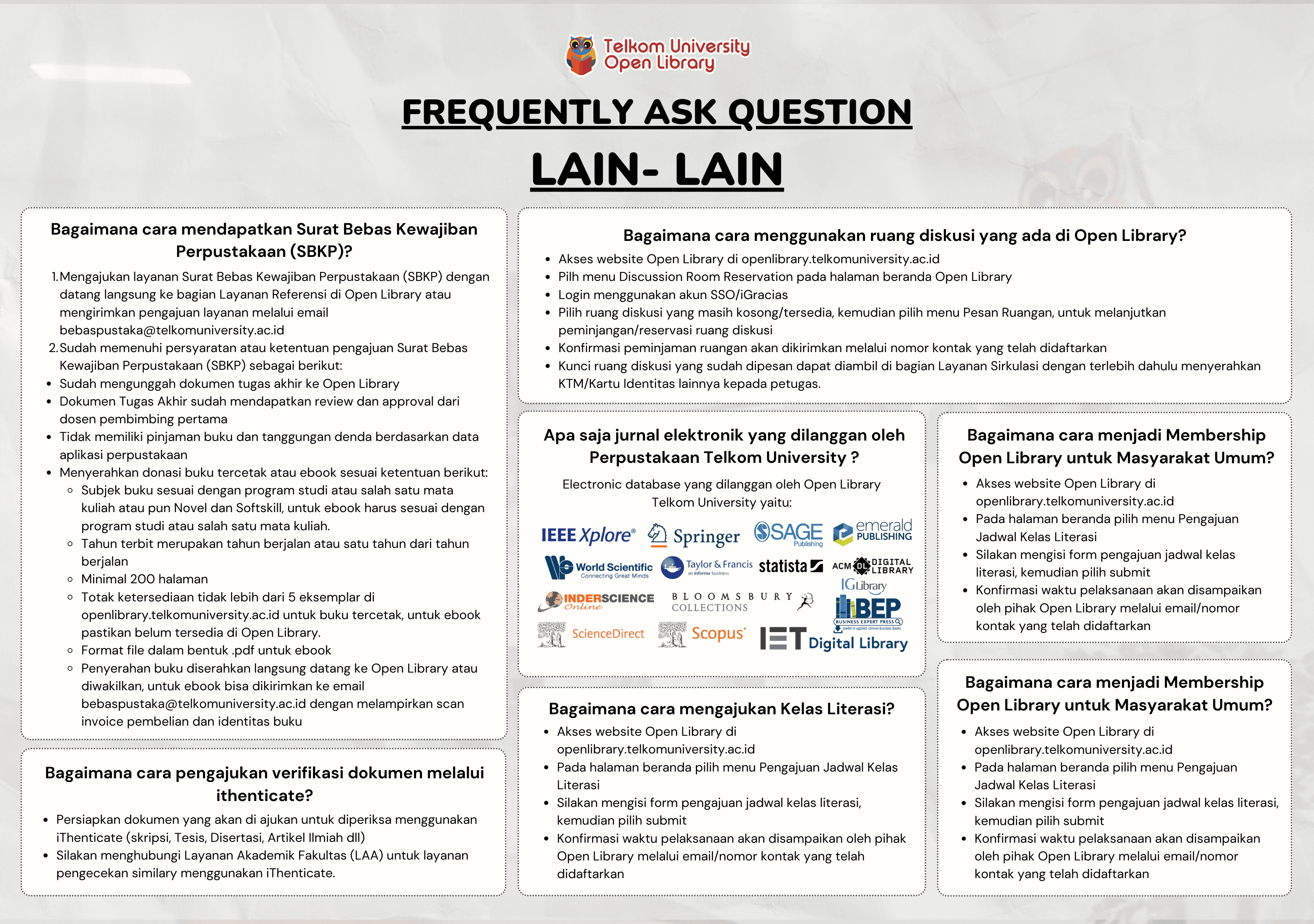
Informasi Umum
Kode
21.21.1227
Klasifikasi
621.382 - Communications engineering, Analog, Digital, Electronic communications, Telecommunications, Digital data and telecommunications engineering
Jenis
Buku - Elektronik (E-Book)
Subjek
Electrical Engineering
No. Rak
Dilihat
183 kali
Informasi Lainnya
Abstraksi
Thanks to recent advances in sensors, communication and satellite technology, data storage, processing and networking capabilities, satellite image acquisition and mining are now on the rise. In turn, satellite images play a vital role in providing essential geographical information. Highly accurate automatic classification and decision support systems can facilitate the efforts of data analysts, reduce human error, and allow the rapid and rigorous analysis of land use and land cover information. Integrating Machine Learning (ML) technology with the human visual psychometric can help meet geologists’ demands for more efficient and higher-quality classification in real time.
This book introduces readers to key concepts, methods and models for satellite image analysis; highlights state-of-the-art classification and clustering techniques; discusses recent developments and remaining challenges; and addresses various applications, making it a valuable asset for engineers, data analysts and researchers in the fields of geographic information systems and remote sensing engineering.
- TTI4P3 - SISTEM KOMUNIKASI SATELIT
- AAK4OBB3 - Sistem Komunikasi Satelit
Koleksi & Sirkulasi
Tersedia 1 dari total 1 Koleksi
Anda harus log in untuk mengakses flippingbook
Pengarang
| Nama | Surekha Borra, Rohit Thanki, Nilanjan Dey |
| Jenis | Perorangan |
| Penyunting | |
| Penerjemah |
Penerbit
| Nama | Springer Singapore |
| Kota | |
| Tahun | 2019 |
Sirkulasi
| Harga sewa | IDR 0,00 |
| Denda harian | IDR 0,00 |
| Jenis | Non-Sirkulasi |